One billion years ago, the granite that formed Enchanted Rock was part of a large pool of magma, or hot liquid rock, perhaps seven miles below the earth’s surface. It pushed up into the rock above in places, then cooled and hardened very slowly, turning into granite. Over time, the surface rock and soil wore away. The pushed-up areas are the domes you see in the park. The domes are a small and visible part of a huge underground area of granite, called a batholith. The Enchanted Rock Batholith stretches 62 square miles; most of it is underground.
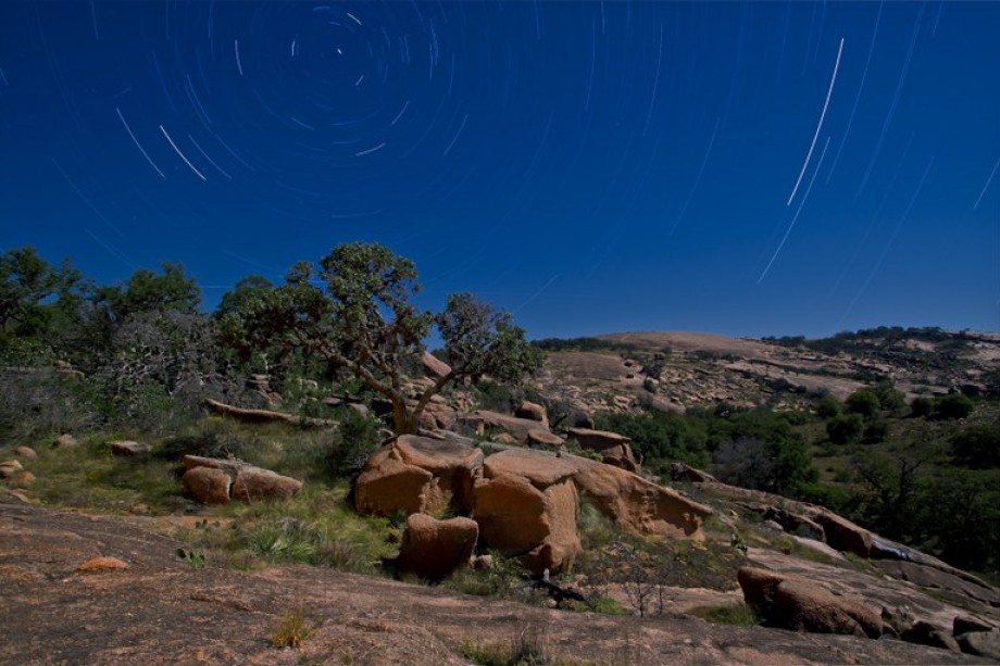
The commanding expanse of the universe and our own Milky Way galaxy presides over the underground batholith and uplifted granite domes of Enchanted Rock.
Preserving the pristine darkness of the night skies is becoming increasingly important to the park so that visitors can enjoy the wonder of the night sky. The skies over the park are still dark enough to view the Milky Way, but they need to be protected from encroaching city lights.
The park has undertaken significant efforts to minimize artificial illumination at night to allow visitors to enjoy the dark skies. Further, the park has installed a dark sky monitor to measure in real-time the relative darkness of the skies above the park each night.
Real-time measurements of sky darkness in the park are displayed below along with an explanation of the measurements.
Sky Quality Meter
The park has a permanently mounted sky quality monitoring station. The monitoring station includes a sky quality meter mounted above the ranger station and pointed at the zenith along with a computer system that logs readings each night.
The computer system posts readings every 15 minutes to this page during the night. The meter is not active during daylight. The Sky Quality Meter is manufactured by Unihedron and recommended by the International Dark Sky Association.
Real-Time Sky Darkness Monitoring
The following information shows real time sky darkness measurements taken from the Sky Quality Meter. These measurements are updated approximately every 15 minutes. No readings are taken during the daylight hours.
The Sky Quality Meter records measurements in a number of ways, but the two most common are:
- Magnitudes per Square Arc Second (Mag/Sq Arcsec)
- Naked Eye Limiting Magnitude (NELM).
The chart below indicates the current sky darkness readings in Mag/Sq Arcsec (magnitudes per square arcsecond) and NELM (naked eye limiting magnitude). The higher the number in Mag/Sq Arcsec and NELM, the darker it is. These measurements are explained in more detail below. A reading greater than 21.5 Mag/Sq Arcsec or 6.0 NELM is considered a very dark sky.

SQM Current Readings
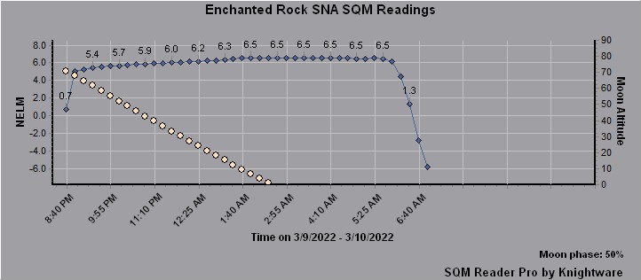
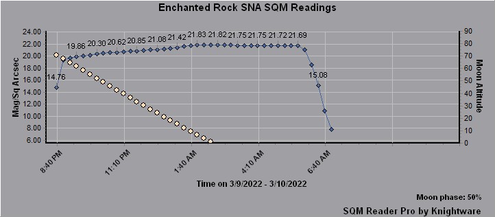
The graphs below show the sky darkness fluctuations over time. One chart is based on NElM measurements and the other is based on Mag/Sq Arcsec. Measurements are taken every 15 minutes and posted to the graph in real time. Measurements are taken starting at sunset and continue through the night until sunrise the next morning.
Fluctuations in sky darkness are caused by the rising and setting of the moon, the milky way passing directly overhead and man-made sources. Readings greater than 22.5 Mag/Sq Arcsec typically indicate the sky is clouded over which makes the environment very dark because there is no star light or any other light coming from the sky.
In the graphs below, the blue line represents the current sky quality meter reading. The line with white circles represents the altitude of the moon in the sky. The current phase of the moon, as a percentage, is indicated in the lower right portion of the graph. Over time you will see the blue line decrease as the moon rises – which means as the moon climbs higher in the sky, the darkness of the sky decreases. Conversely, you will see the blue line increase as the moon sets – which means as the moon gets lower in the sky, the darkness of the sky increases.

Naked Eye Limiting Magnitude

Magnitudes per Square Arc Second
A number of factors contribute to how dark the night sky is, including the moon, milky-way, airglow from gases in the atmosphere, and the largest contributor – light pollution from man-made sources of illumination.
Current moon phase information for Enchanted Rock State Natural Area can be found here.
A current moon phase calendar can be found here.
Explanation of Magnitude
Both measurements use the term “magnitude” which comes from the term “apparent magnitude” that astronomers use to describe how bright an object appears in the night sky. Apparent magnitude was originally based on a scale from 1 to 6, with 1 representing the magnitude of a particular reference star and 6 representing the faintest object that can be seen by the naked eye.
Going from one magnitude to another represents a change in brightness of 2.5 times. This means an object of magnitude 3 is 2.5 times brighter than on object of magnitude 4. The important point to remember is that brighter objects have smaller magnitudes and fainter objects have larger magnitudes. The magnitude scale can even have negative numbers which means the object is very bright. For example, the brightest star in the sky is Sirius and has an apparent magnitude of -1.6. Sirius is near the constellation Orion in the winter sky.
Therefore, Naked Eye Limiting Magnitude or NELM simply represents the faintest magnitude that your naked eye can perceive under the particular sky being measured. A NELM of 6.0 means you will be able to see objects as faint as magnitude 6.0 which is about as faint as the human eye can see. A NELM of 2.0 on the other hand, means the sky is relatively bright due to the presence of the moon in the sky or you could be in an urban location with a lot of light pollution. Some of the darkest locations on planet Earth have a NELM of around 7.0 to 7.5. Very dark indeed.
Some examples of objects with varying magnitudes are listed below.
Apparent Magnitude |
Celestial Object |
| -26.7 | Sun |
| -12.6 | Full Moon |
| -4.4 | Venus (at brightest) |
| -3.0 | Mars (at brightest) |
| -1.6 | Sirius (brightest star) |
| +3.0 | Naked eye limit in an urban neighborhood |
| +5.5 | Uranus (at brightest) |
| +6.0 | Naked eye limit |
| +9.5 | Faintest objects visible with binoculars |
Explanation of Mag/Sq Arcsec
Astronomers also use Mag/Sq Arcsec to measure relative sky darkness. There is even a formula to convert from NELM to Mag/Sq Arcsec. Mag/Sq Arcsec is simply the apparent magnitude (discussed above) for a certain square area of the sky represented in arc seconds. A square arc second is a square area of the sky that is one arc second on each side. An arc second is a very small measurement. For example, Jupiter looks very small in the sky, but through binoculars it does have a disk-like shape and a small diameter. Jupiter’s angular diameter ranges from 30 to 50 arc seconds. Therefore, Mag/Sq Arcsec means the brightness (expressed in apparent magnitude) of a one arc second square area of the sky. This is very small and almost a single point in the sky.
The Bortle Scale
The Bortle Dark-Sky Scale is a numeric scale that measures the night sky’s naked eye brightness and stellar limiting magnitude of a particular location. It quantifies the ability to observe celestial objects and the interference caused by light pollution and sky glow. John E. Bortle created the scale and published it in the February 2001 edition of Sky & Telescope magazine to help observers compare the darkness of observing sites. The scale ranges from Class 1, the darkest skies available on Earth, through Class 9, inner-city skies. In the chart below, the Bortle scale is depicted with a color coding scheme along with Naked Eye Limiting Magnitude (NELM) and Mag/Sq Arcsec so you can compare the different measurements.
Bortle Scale |
Title |
NELM |
Mag/Arcsecond |
Description |
| 1 | Excellent Dark Sky Site | 7.6 – 8.0 | 22.00 – 21.99 | Zodiacal light visible; M33 direct vision naked eye object; Regions of the Milky Way cast obvious shadows on the ground; surroundings basically invisible. |
| 2 | Typical True Dark Sky Site | 7.1 – 7.5 | 21.99 – 21.89 | Highly structured summer Milky Way; distinctly yellowish zodiacal light bright enough to cast shadows at dusk and dawn. |
| 3 | Rural Sky | 6.6 – 7.0 | 21.89 – 21.69 | Low light domes (10 to 15 degrees) on horizon. M33 easy with averted vision. Milky way shows bulge. |
| 4 | Rural / Suburban Transition | 6.2 – 6.5 | 21.69 – 21.25 | Zodiacal light seen on best nights. Milky way shows much dark lane structure with beginnings of faint bulge. M33 difficult even when above 50 degrees. |
| 4.5 | Suburban Sky | 5.9 – 6.2 | 21.25 – 20.49 | Some dark lanes in Milky Way but no bulge. Washed out Milky Way visible near horizon. Zodiacal light very rare. Light domes up to 45 degrees. |
| 5 | Bright Suburban Sky | 5.6 – 5.9 | 20.49 – 19.50 | Milky Way washed out at zenith and invisible at horizon. Many light domes. Clouds are brighter than sky. |
| 6 – 7 | Suburban / Urban Transition or Full Moon | 5.0 – 5.5 | 19.50 – 18.38 | Milky Way at best very faint at zenith. M31 difficult and indistinct. Sky is grey up to 35 degrees. |
| 8 – 9 | City Sky | 3.0 – 4.0 | < 18.38 | Entire sky is grayish or brighter. Familiar constellations are missing stars. Most people don’t look up. |
Sky Quality Monitoring Location
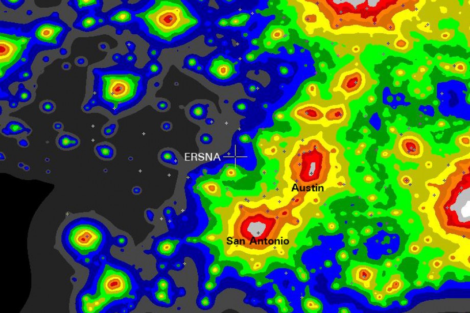
The Sky Quality Monitoring station is located at the park. The map below shows the sky glow around the park with colors that match the Bortle scale.
Enchanted Rock is designated at the ERSNA crosshairs. The cities of Austin and San Antonio are indicated.
Clear Sky Chart
The park also has a Clear Sky Chart. A Clear Sky Chart is an astronomer’s forecast about sky conditions, including, darkness, cloudiness, transparency and the seeing quality. More information about the Clear Sky Chart can be found here.


